
Frigiliana Map and Guide
Frigiliana map, holiday, car hire, airport transfers, rentals, golf.
View Frigiliana in a larger map
Detailed Street Map of Frigiliana Spain
Frigiliana Map: Zoomable road map of Frigiliana a pretty pueblo blanco ("white village") just inland from Nerja on the Costa del Sol, in Andalucia, Spain.
Using the buttons on the top left you can 'zoom' and 'pan' to get a detailed road map of Frigiliana and plan your visit to the village.
By zooming out you can also view the other nearby areas of Nerja, Maro, Cuevas de Nerja (Nerja Caves), Torrox, Torrox Costa, Punta Lara and Cañamiel.
Frigiliana Andalucia: Situated about 6 kilometres inland from the coastal resort of Nerja, the pretty town of Frigiliana is one of the typical "white villages" of the region. A popular day tip destination from Nerja, Frigiliana sits on the lower slopes of the Sierra de Tejeda surrounded by orchards and farm land, and offering spectacular views of the coastline and the Higueron River.
The town in Andalucia has a population of around 2,000 and is a maze of narrow cobbled streets, lined with pretty whitewashed houses, draped with bougainvillea, it has formerly held the title of "Prettiest Village in Andalucia" (1998), it has won numerous other awards for its charm and beauty.Frigiliana has a somewhat chequered history and was settled by both Phoenicians and Romans in the centuries BC, during the Arab occupation of the Iberian peninsular a fortified castle was constructed above the town , and it was here that there was a bloody battle during the rebellion of Alpujarras (1568), there was a seige by the Christian forces and eventually the castle was totally destroyed and its Moorish inhabitants killed or deported, according to legend, many threw themselves from the walls of the castle rather than be captured by the Christians and their bones can still be found in the surrounding countryside, a colourful fiesta held every June, commemorates the battle.
So, Frigiliana no longer has a castle as you would expect and scant remains of the former fortress can be seen on El Fuerte hill above the town.
In the back streets of Frigiliana you will find numerous charming little craft shops and galleries, where you can purchase a memento of your visit, there are a variety of handicrafts for sale including fine ceramic work, basketware, linen and lace. Shaded squares, house local bars where you can taste the famous locally produced sweet Malaga dessert wine. You can use the zoom feature on the Frigiliana map above to get a detailed street mao of Frigiliana and find you way around its narrow streets.
Frigiliana benefits from typical Costa del Sol weather conditions, with plenty of sunshine.
Find your way to the town using the Frigiliana map at the top of this page, Frigiliana can be accessed via the MA-5105 from the AP-7 motorway, it is about 6 kilometres from Nerja and around 56 kilometres from Malaga.
Frigiliana Holiday Rentals
Rental Properties in Frigiliana - Holidays - Long Term - Short Breaks - Golfing Holidays
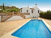 |
Frigiliana Holiday Rentals - 3 Bedroom Villa - Private Pool - Sleeps 6 Attractive 3 bedroom detached villa with private pool offered for holiday rentals in Frigiliana. Bathroom, shower room, satellite TV, dishwasher, terrace, parking. Full details & booking here: |
|
MORE FRIGILIANA HOLIDAY RENTALS CLICK HERE>> |
||
Frigiliana airport driving distances: Malaga airport to Frigiliana is a driving distance of 72 kilometres (44 miles), Granada airport to Frigiliana is a driving distance of 115 kilometres (72 miles). (see Frigiliana map above)
Places on Frigiliana map above: Torrox - Nerja
Frigiliana Map - Guide to Frigiliana - Street Map of Frigiliana - Weather - Detailed Frigiliana Map
Related: Frigiliana Weather - Costa del Sol Information - Salobrena - Builders
HOME